GIS study on suitable AWE sites in Ireland
Identifying deployment opportunities for Airborne Wind Energy in Ireland
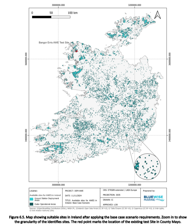
This report presents the site identification analysis for Airborne Wind Energy (AWE) in Ireland under the DEM-AWE project. Using GIS and publicly available data, the study evaluates suitable locations for AWE deployment, considering environmental, geographic, and logistical factors, adapting methodologies from the one made for Germany (Coca-Tagarro, I. 2023).
Key site selection criteria include slope, operational radius, and proximity to settlements. Data from OpenStreetMap, NASA, and Copernicus were analyzed using QGIS. The study identified 1,600–1,800 km² of deployment area and 9,300–10,700 km² of operational area, with nearly 6,000 sites and up to 24,000 devices, supporting up to over 30 GW of AWE capacity. Counties Mayo, Donegal, and Kerry emerged as high-potential areas due to favorable geography and low population density.
Key site identification factors:
Adequate space for Ground Stations (GS) and AWE operation.
Minimal collision risks with obstacles or aircraft.
Safe distances from public spaces, airports, and protected areas.
Suitable terrain for site development.
👉 Zenodo repository: Site Identification Analysis for AWE Devices. A case study in Ireland
Ireland offers strong potential for AWE due to its land availability and lower forest coverage. It is highly important, to the point that Bangor Erris landscape, in County Mayo, hosts an AWE test site, established by RWE in collaboration with Kitepower and also supported by Interreg North-West Europe, which had its maiden flight in September 2023. Now the Dutch AWE company continues to operate the site with a demonstration of their K-BESS solution.
The DEM-AWE team is assessing AWE deployment potential using an analytical tool developed by BlueWise Marine, previously applied in Germany. Results showed potential capacities of 12-108 GW, influencing Germany’s Renewable Energies Act in 2024.
The project will continue refining site identification for key countries previously evaluated as feasible lands to deploy Airborne Wind Energy systems like France, Spain, and the Netherlands, integrating geographic, technological, and regulatory constraints.